William Buehler - Reshel Grids |
Lincs R/H 2 |
 E MAIL 7
LINCOLN CATHEDRAL/LOUTH/WOLDS/BELMONT/WASHINGTON.
Bill,
With everything being connected to everything else, entangled…. I researched heights of buildings in Lincolnshire.
Lincoln cathedral became the highest building in the world in 1311 surpassing
the GP of giza. The list of the tallest building may help you locate other
important systems within the reshel worldide grid....the land /building
heights will be related to how it works I think.....as is being shown in
Lincs.
http://en.wikipedia.org/wiki/List_of_tallest_churches_in_the_world
The list may aid the completion of the grid...and where to look for other
systems. Interesting to note Lincoln was only surpassed in the 1800's by a
monument in Washington...again a link with the area, along with the pilgrim
fathers/Boston...to the US.
Washington as is quite well known, has sacred geometry built into its layout
/design also.
http://www.geocities.com/jussaymoe/dc_symbolism/
Lincoln also had the largest diocese in Europe , going as far as Oxford..200
miles approx ….I feel there may be another system around Lincoln, involving the cathedral ..tieing it all in to one big complex. Lincoln is north of Bruer,..
..and looks and feels like something should be there... If you have any ideas as to the possible grid to look for in relation to whats at the other sites it may help.....Lincoln is littered with churches and heavily built up.
Louth , a small town to the east of the Maltby geometry(not marked on map) has
the tallest spire of any Anglican church in the UK....one of the pentacles
encased in the Maltby geometry has a line feed into it.
Also Louth is known for some religous rebellion...and was the origin of the
'pilgrimage of grace', ...they marched on Lincoln.
http://en.wikipedia.org/wiki/Pilgrimage_of_Grace
Lincolnshire wolds background here.
http://en.wikipedia.org/wiki/Lincolnshire_Wolds
Belmont Aerial /height..here.
http://en.wikipedia.org/wiki/Belmont_transmitting_station
This again I believe is suppressing the site/area and affecting
peoples natural connection to the land around them.
There is much discussion as I'm sure you know as to the negative effects of
tv/phone masts...on the people living around them....the stem of the aerial at
Belmont( mount of BEl/baal) is covered in phone transmitters and receivers .
I have attached the Benniworth springs GP image/raised cap, line goes straight
through it……line runs from callainish..58 11' 50.66" N.......6 44' 50.55" W
depicted as the stones on google earth. …to the red dot centre of kings lynn
as depicted on google earth...this is the line depicted on the attachment...hits the springs right on the button...and exits lincs at New Leake on the southern coast of the county......but this will be off to a direct hit on Malta as Tom mentioned.
Best
E MAIL 7
LINCOLN CATHEDRAL/LOUTH/WOLDS/BELMONT/WASHINGTON.
Bill,
With everything being connected to everything else, entangled…. I researched heights of buildings in Lincolnshire.
Lincoln cathedral became the highest building in the world in 1311 surpassing
the GP of giza. The list of the tallest building may help you locate other
important systems within the reshel worldide grid....the land /building
heights will be related to how it works I think.....as is being shown in
Lincs.
http://en.wikipedia.org/wiki/List_of_tallest_churches_in_the_world
The list may aid the completion of the grid...and where to look for other
systems. Interesting to note Lincoln was only surpassed in the 1800's by a
monument in Washington...again a link with the area, along with the pilgrim
fathers/Boston...to the US.
Washington as is quite well known, has sacred geometry built into its layout
/design also.
http://www.geocities.com/jussaymoe/dc_symbolism/
Lincoln also had the largest diocese in Europe , going as far as Oxford..200
miles approx ….I feel there may be another system around Lincoln, involving the cathedral ..tieing it all in to one big complex. Lincoln is north of Bruer,..
..and looks and feels like something should be there... If you have any ideas as to the possible grid to look for in relation to whats at the other sites it may help.....Lincoln is littered with churches and heavily built up.
Louth , a small town to the east of the Maltby geometry(not marked on map) has
the tallest spire of any Anglican church in the UK....one of the pentacles
encased in the Maltby geometry has a line feed into it.
Also Louth is known for some religous rebellion...and was the origin of the
'pilgrimage of grace', ...they marched on Lincoln.
http://en.wikipedia.org/wiki/Pilgrimage_of_Grace
Lincolnshire wolds background here.
http://en.wikipedia.org/wiki/Lincolnshire_Wolds
Belmont Aerial /height..here.
http://en.wikipedia.org/wiki/Belmont_transmitting_station
This again I believe is suppressing the site/area and affecting
peoples natural connection to the land around them.
There is much discussion as I'm sure you know as to the negative effects of
tv/phone masts...on the people living around them....the stem of the aerial at
Belmont( mount of BEl/baal) is covered in phone transmitters and receivers .
I have attached the Benniworth springs GP image/raised cap, line goes straight
through it……line runs from callainish..58 11' 50.66" N.......6 44' 50.55" W
depicted as the stones on google earth. …to the red dot centre of kings lynn
as depicted on google earth...this is the line depicted on the attachment...hits the springs right on the button...and exits lincs at New Leake on the southern coast of the county......but this will be off to a direct hit on Malta as Tom mentioned.
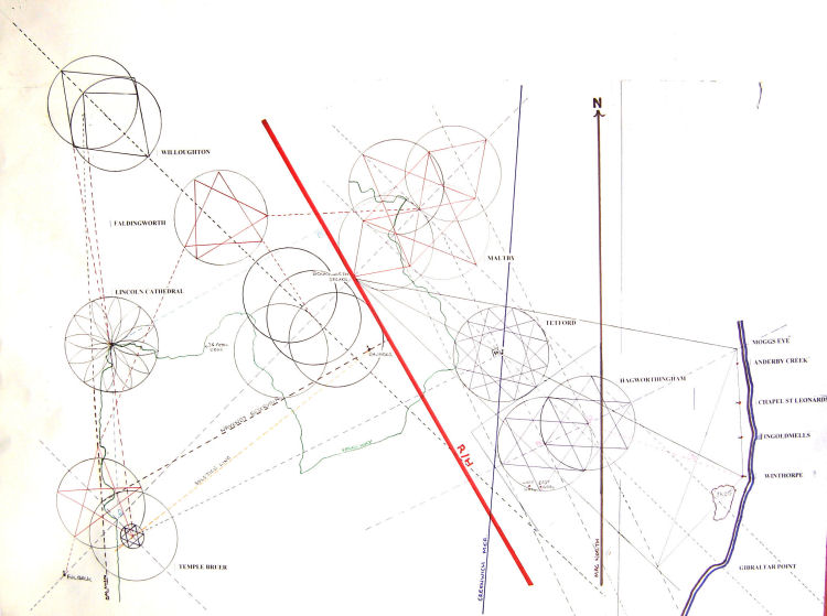
BestTony.Bill, You were spot on with West Ashby, its the pdf RH grid diagram that is deceptive. I do not have Rosslyn on my large UK map...but it does show Temple. (C) http://www.shameer-orion.org/pdf/BorthwickSunLine01b.pdf I marked both Rosslyn and Temple as points R and U on the graphic. They list the OS coordinates for each. Rosslyn is much more important than Temple. The main magnetic grid for Edinburgh, complementing the True geographic grid, is from Templar Wood, through Rosslyn, to Temple (the church ruin there). Rosslyn is the connecting point of both Magnetic and True grids. Just as a rough guide connected Temple to Kings Lynn marked the points that it went through in Lincolnshire then transferred it over to the large Lincolnshire OS maps....which meant connecting Wrangle near Boston to a point just west of Ludford, north Lincs. The RH line does go east of Horncastle but comes right through West Ashby . But there is no way it will connect with the vesica axis NE line from Bruer there...as a natural convergence of each line following it’s set course. (C) There are two lines I'm referring to, connecting with the RH axis: the vesica axis and the Shaka line from the center of the vesica, about a 4 degree expanding sector. They wouldn't connect except in the Center. If you and Jackie do a process you might make that Center point into the primary Pillar in the Dione Couplet format. Probably the most important single point in the Grid. The point where the two lines meet is North Lincs near the highest point between Kent and Yorkshire..200 miles approx. ...not far from the Bel mont tower/aerial....in fact it may be exactly on it....the more grid references I have for RH line the more accurate it will be. The vesica line is very accurate...being contained within the Lincs maps although some maps have to be joined carefully...and checked for movement....but there is much to verify that line with the important abbey at Bardney falling in as well as the other sites mentioned earlier...and of course the WARREN and COCKED HAT being duplicated near/approaching vesica/RH convergence point /area…just like Bruer. The angle the vesica line hits the RH line based on only rough work up to now is ...78 degrees, but there is enough interesting geometry I can sense in the area locally including the other templar site at Maltby, a few miles away to be able to tap into the RH line from the vesica line at 90 degrees. I will have to discover the geometry for the ancient area where the lines meet....there is a lot to play with many earth works,churches,tumuli..hill forts etc. Best Tony E MAIL 8 COCKED HAT/ BELMONT /KINGS LYNN Tony, A "cocked hat" is a navigational fix that makes a triangle. Ideally a fix has at least 3 lines meeting perfectly but it rarely happens. One pinpoints a median WAG (Wild-Assed Guess) inside the triangle. The place name may be relating to 3 leys coming through there and there will be a resultant "power point" within the triangle. The "hat" may be a much larger triangular area with the place being the power resultant point. One line might even be curved. In this area also are many earthworks....the line then continues to BEL mont house where the large TV Aerial sits called BELMONT.....bel/baal...sun icon. "Bal" was once a pure high god before the religion fell. A valid Metatronic project might still, in nonlinear Time, be tuned in at a decent level. "Bal" in Hebrew means "failure, nothing, overflow, mix, fodder, make away with by swallowing, to destroy, the heart, feed cattle." The meanings are corrupted but two are very relevant: "heart and nothing." This was the number 58 the Templars used: Noach (Noah) as the Silence/Rest and in the other direction (8 + 50) it means Grace. This is foundation field for all actions. Does the RH line start at Rosslyn chapel Bill?...If so I have my first point, Kings Lynn another but ideally a church or marker in Kings Lynn would mean a more accurate line....a third point would make it more accurate again....preferably the exit point as it leaves the uk, a coast grid coordinate...place/town/hill. (C) Start it at the Callanish Stone site on Lewis and end it at Malta. It should go through Edinburgh somewhere but the Edinburgh Reshel grid is 40 miles in diameter and Rosslyn is its "Resh" pole, synthesizing the whole thing. Rosslyn taps into any Metatronic action there. Any important sites near it but not on it would connect via the Shaka projection to the axis. Lynn: as lin, linne in Scot Gaelic means a number of things including "Lion, line, brood hen and brood of 12, various bodies of water such as a cataract, bay, lake, etc." (Water representing a Time continuum reality frame.) "King's Lynn" is implying a major Line-of-12 ...as a Druid's Cord with 12 knots and two free ends to make a 13th. So there are probably 12 major points on or near the Line. A linear zodiacal temple. Also, it might be like the Michael-Mari Line: a pair of twisting innertwining "dragon" lines where the line is the resultant combination of the two of them as a resultant; another example of the Shaka action. Any wide collection of points can be projected to a straight line; this is how staffs are made as well as star lines, et al. I think the RH axis goes on out into the North Atlantic to a sea-temple or UT (Ultra Terrestrial) ship portal or base, but for our purposes the Rutan temple site at the Callanish point is doable. Bill . 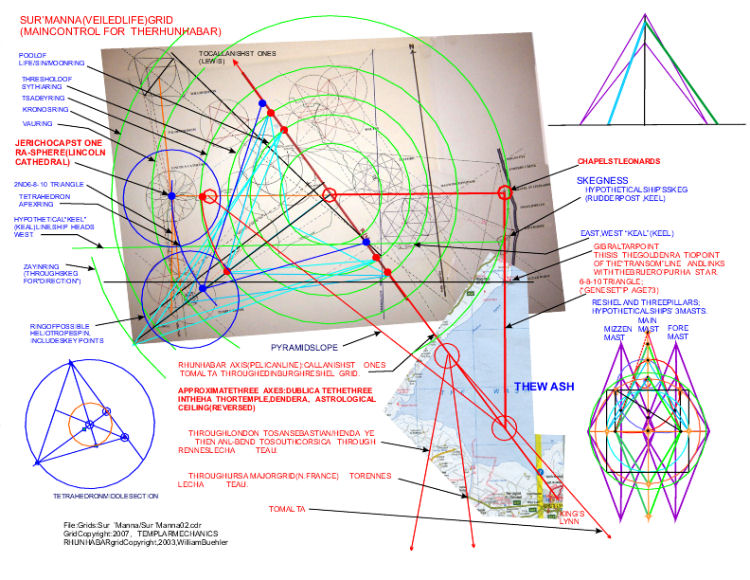 |
|
This site is © 2008-2011 Templar Mechanics. All rights reserved. Materials must not be reproduced without prior consent of Templar Mechanics. Any unauthorised reproduction or copying of its content will result in legal action being taken. |
For all enquiries, please e-mail enquiries@templarmechanics.com |